Integrated Flood Management
Integrated Flood Management (IFM) integrates land and water resources development in a river basin, within the context of Integrated Water Resources Management (IWRM), with a view to maximizing the efficient use of flood plains and minimizing loss to life. Thus, occasional flood losses can be accepted in favor of a long-term increase in the efficient use of flood plains.
As part of Romania’s plans to upgrade integrated water management capabilities, in the context of increasing the all decision levels staff capacity the E-learning manual focus on the four aspects of disaster management as they relate to floods – mitigation, preparedness, response, and recovery. More specifically, the E-learning manual presents the roles and institutional responsibilities of water management system and of the emergency planners in monitoring, impact analysis, alert and warning, response, and remediation for floods, and associated spill. Adequate inter-linkage between water management activities and Emergency Situations Planning practice at the international levels was revealed. Different web sites presenting legal and institutional aspects of the Integrated Flood Management were presented, as well as different projects sites, developed under the umbrella of the Flood Risk Management Research Program or as Regional Development Program.
This E-learning manual is a review of the projects results and of the last 5 years guidelines, manuals of the best practices and documents related with flood risk management. The aims is to give the base information at the world level or through national committees, about the launched initiatives under the aegis of UN’s International Decade for Natural Disaster Reduction and its permanent successor, the International Strategy for Disaster Reduction (ISDR). More specifically, at the EU level, on 18 September 2007 the Directive on the assessment and management of flood risks was adopted which will be coordinated and synchronised with the Water Framework Directive (WFD) in the implementation phase as far as maps/risk assessments (2013) as well as planning (by 2015) and public participation (from 2012), and will contribute at the first WFD River Basin Management Plan due 2009, with its specific reports and adequate solutions for flood management.
One core objective of the course is to provide a web platform for dialogue and support of the implementation of the principles of flood emergency planning and to provide the needed information for an easier Flood Directive implementation. For information about the Directive on the assessment and management of flood risks, please visit the European Commission’s Website special pages on Flood risk management:
http://ec.europa/environment/water/flood_risk/index.htm.
The other core objective is information exchange on Flood forecasting and on Flood mapping, to enable students to learn from good practices and experiences in integrated flood risk management and the implementation of the Action Plan for Flood Protection and support of competent national authorities at the Danube Basin level and for other trans-boundary basins.
Dr. Mary-Jeanne Adler
Director of Emergency Situations Management
Ministry of Environment and Sustainable Development
This module is coordinated by Dr. Drobot
The lessons were prepared by Dr. Mary-Jeanne Adler
Module Participants
Communication Point:
- Announcements Forum
- Discussion Forum
- Chat
- References:
- References PDF document
One flood scenario, three different questions
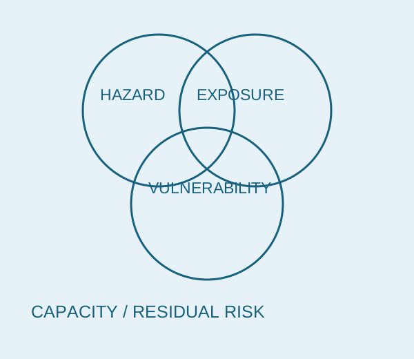
A hazard map is not a complete account of harm. Use a scenario card to distinguish the event, what is present and what makes those people or assets susceptible. This classroom example is fictional and supplies no property-level assessment or live warning.
- Describe the hazard with a location, extent, depth or intensity, likelihood and source date where available. Keep unknown fields empty. Do not turn an illustrative depth into a forecast for a named street.
- List exposure within that scenario: people, buildings, essential equipment and services. Count the relevant unit and period; an inventory of buildings is not a count of residents.
- Describe vulnerability and capacity separately. Ground-floor equipment, limited mobility and an unavailable evacuation route require different questions. Avoid judging an individual’s abilities from an address or a demographic label.
- Change one condition and say which category changed. Then note residual risk and the responsible source for actual advice. Follow local authorities for warnings and emergency instructions, rather than this teaching diagram.
| Field | Example or check |
|---|---|
| Scenario — invented | A hypothetical flood reaches a ground floor. No real location, probability, depth estimate or warning is asserted. |
| Exposure | A library’s electrical cabinet and stored books are on that floor. Record people present separately; the inventory says nothing about occupancy. |
| Vulnerability / capacity | Equipment height, waterproofing, staff warning arrangements and accessible exit routes need evidence; they are not inferred from a photograph. |
| One change | Moving the cabinet above the scenario water level changes equipment exposure. It does not remove the flood hazard or prove the building safe. |
| Scenario worksheet | Hazard/source/date __; exposed people/assets __; vulnerability evidence __; capacity __; changed condition __; residual risk __; authority advice __. |
UNDRR defines disaster risk through hazard, exposure, vulnerability and capacity. The card above is an original reading exercise for the historical course topic, not a current EDUCATE course enrolment or university service.
Sources: UNDRR — disaster risk terminology